Mangrove Genus Distribution Around the World
Abstract
Mangroves are nature-based solutions for coastal protection; however, their effectiveness in attenuating waves and stabilizing sediment varies depending on their species-specific architecture and frontal area. Hydrodynamic models are commonly used to predict the protective capabilities of mangroves, but the lack of information on species or genus distribution can lead to significantly different outcomes. Data on the frontal genus of mangroves facing waves and tides can enhance the accuracy of hydrodynamic models in forecasting the protective benefits offered by mangroves. The identification of frontal species globally from existing mangrove zonation diagrams has enabled the creation of a global mangrove genus distribution map, with the objective of enhancing the precision of hydrodynamic models. This dataset is valuable for researchers in coastal engineering, marine science, wetland ecology, and blue carbon studies.
Global Significance of Mangroves in Coastal Protection
Cities worldwide are increasingly considering nature-based solutions for coastal protection to address the escalating erosion and flooding arising from climate change. While mangroves have garnered attention for their important role, their effectiveness in wave attenuation and flood reduction varies significantly based on factors like areal extent, water depth, tide stage, density, and genus-specific architecture. Genera with substantial aboveground root systems, like Rhizophora spp., have demonstrated the capacity to reduce nearshore wave heights by as much as 70%, contrasting with genera such as Avicennia spp. that have a smaller frontal area and comparatively lower impact on waves. To assess the suitability of mangrove forests as natural defenses, hydrodynamic models must incorporate the variability in mangrove tree architecture attributed to different genera and species.
Challenges in Representing Mangroves in Hydrodynamic Models
Hydrodynamic models play a crucial role in predicting the influence of vegetation on coastlines concerning flooding and erosion, where mangroves are often simplified in these models as a ‘drag coefficient’ or ‘2D rigid cylinders.’ While these methods represent advanced techniques, their accuracy is limited unless they incorporate the specificity of mangrove genera and species exposed to waves, known as the ‘frontal species.’ The ability of mangroves to withstand coastal hazards is significantly influenced by the architecture of frontal vegetation within the forest. Despite existing data on the architecture of specific mangrove genera and species and datasets on mangrove distribution, biomass, and canopy height, a spatial dataset highlighting the distribution of mangrove genera/species is currently lacking.
Climate Change and Mangrove Effects on Climate Change
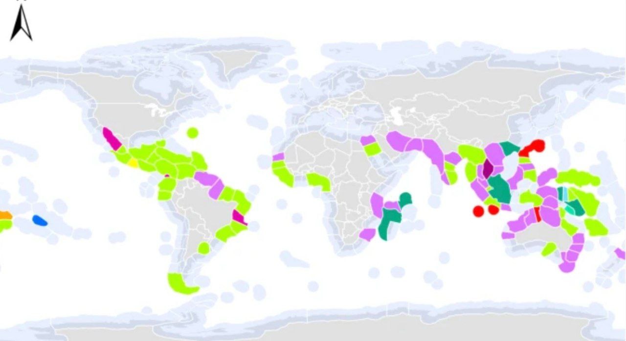
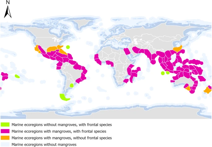
This dataset provides a global spatial layer identifying the frontal mangrove species for each marine ecoregion of the world (MEOW)24. The outputs include a spatial layer of frontal mangrove genera, and species where available, a comprehensive dataset of all mangrove zonation data and an interactive spatial model illustrating the location of zonation diagrams using ArcGIS StoryMaps.
The benefits of this spatial layer are two-fold; 1) a new global spatial layer to include the species of mangroves, and 2) this can be used in coastal engineering models to more accurately prescribe the roughness factor, drag or architecture in coastal engineering models. This spatial layer has value for both marine ecologists, coastal engineers and conservation scientists.
Methods
A systematic literature search was conducted to identify published diagrams outlining the mangrove species zonation observed for a given area. The data extracted from these diagrams included the location, mangrove species present, discrete order of the mangrove species within the intertidal zone (from their seaward to landward location) and marine ecoregion24. ArcMap 10.825 software was used to develop the Bunting, et al.15 mangrove presence spatial data into a mangrove species-specific map, categorised by marine ecoregions24.
Structured literature search
A systematic literature search was conducted using the University of Queensland’s library search tool, which queries databases such as Web of Science and SCOPUS. The search was conducted on and before 1st November 2022.
Search criteria
Topic search criteria included the following terms: (‘country name’) AND (‘mangrove + zonation’ OR ‘mangrove + profile’). All countries that have an ocean border (141 total) were included in the ‘country name’ search criteria. If any combination of two or more search terms appeared in the title or abstract, the article was shortlisted and later read in total to identify eligibility.
Eligibility for inclusion
Articles returned by the literature search were included in the meta-analysis if they included a diagram or image of a mangrove profile illustrating the zonation of different mangrove species. The review yielded 195 eligible studies and 510 zonation diagrams.
Attaching locations to each zonation observation
Specific locations of the zonation observation were recorded for 68 of the diagrams. For most of the zonation diagrams, the exact latitude and longitude were not recorded but included the location name. Google Earth was used to visually inspect the area outlined in the article and a location where mangroves appeared to be present was selected. Observations whose locations have been selected in this manner have been highlighted in the original Excel dataset.
Relevance for inclusion
Google Earth was used to visually inspect each the location of each mangrove transect to ensure mangroves were present in the area and relevant. For instances where a mangrove zonation diagram was relevant to a region larger than several MEOW such as for ‘climatic regions’, these data were omitted from the spatial layer but still included in the original Excel dataset. These observations have been highlighted by including a description of where they are relevant but with ‘NA’ in the latitude and longitude.
Developing the spatial layer
Using ArcMap 10.8, the marine ecoregion24 spatial layer was overlayed onto the mangrove presence spatial layer15. The marine ecoregions mapped by Spalding, et al.24 were used as a proxy for the varying conditions which may contribute to mangrove zonation. Marine ecoregions where mangroves from Bunting, et al.15 were not present, were removed from the dataset.
Using the latitude and longitude of each mangrove zonation observation, a frontal species was assigned to the relevant marine ecoregion (Fig. 1). Mangrove frontal species were selected based on the diagram from the relevant marine ecoregion. Where multiple diagrams exist for the same marine ecoregion generally showing similar zonation patterns, the most common species was adopted.

